Context:
Recently, Nepal's Prime Minister Balendra Shah, while raising the issue of the "India–Nepal border dispute" in the Nepali Parliament, called for the involvement of China and Britain to resolve it. In response, India firmly rejected any role for third parties, reiterating that the boundary issue is a bilateral matter to be resolved through existing diplomatic mechanisms between the two countries.
Historical Basis of the Dispute:
-
-
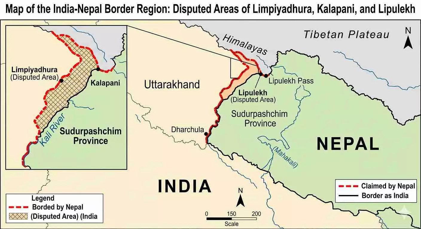
- The origins of the dispute can be traced to the Treaty of Sugauli signed in 1816 following the Anglo-Nepalese War. The treaty defined the boundary along the Mahakali (Kali) River, with Nepal retaining territory east of the river and British India controlling land to the west.
- The main source of disagreement is the lack of clarity regarding the river’s exact origin. Nepal argues that the Mahakali River originates from Limpiyadhura, whereas India considers its source closer to the Kalapani–Lipulekh region. This differing interpretation has led to competing territorial claims over Kalapani, Lipulekh, and Limpiyadhura.
- The origins of the dispute can be traced to the Treaty of Sugauli signed in 1816 following the Anglo-Nepalese War. The treaty defined the boundary along the Mahakali (Kali) River, with Nepal retaining territory east of the river and British India controlling land to the west.
-
Nepal’s Stand:
-
-
- Nepal maintains that Kalapani, Lipulekh, and Limpiyadhura lie east of the Mahakali River and therefore belong to Nepal under the Treaty of Sugauli. It supports its claim through historical maps, administrative records, and hydrological interpretations.
- In 2020, Nepal released a revised political map incorporating these territories within its borders and later amended its Constitution to include the map. Nepal has also objected to infrastructure projects and India–China agreements concerning the Lipulekh route that were undertaken without its participation.
- Nepal maintains that Kalapani, Lipulekh, and Limpiyadhura lie east of the Mahakali River and therefore belong to Nepal under the Treaty of Sugauli. It supports its claim through historical maps, administrative records, and hydrological interpretations.
-
India’s Stand:
-
-
- India considers the disputed region an integral part of Uttarakhand and points to its long-standing administrative control over the area. It highlights the use of the Lipulekh Pass route for the Kailash Mansarovar Yatra since 1954 as evidence of historical administration and connectivity.
- India has consistently maintained that the dispute should be resolved through bilateral dialogue and peaceful negotiations. It views Nepal’s revised map as a unilateral action and continues to advocate existing diplomatic mechanisms for addressing boundary issues.
- India considers the disputed region an integral part of Uttarakhand and points to its long-standing administrative control over the area. It highlights the use of the Lipulekh Pass route for the Kailash Mansarovar Yatra since 1954 as evidence of historical administration and connectivity.
-
Strategic and Geopolitical Importance:
-
-
- The disputed region is strategically significant because it lies near the India–Nepal–China tri-junction. Control over the area has implications for border security, military logistics, and connectivity in the Himalayan region.
- The Lipulekh Pass also serves as an important route for the Kailash Mansarovar Yatra, making the region culturally and religiously significant. Additionally, increasing India–China cooperation on connectivity through this route has heightened Nepal’s concerns regarding its strategic interests.
- The disputed region is strategically significant because it lies near the India–Nepal–China tri-junction. Control over the area has implications for border security, military logistics, and connectivity in the Himalayan region.
-
Why Does the Dispute Persist?
The dispute continues due to multiple factors:
-
-
-
- Ambiguity regarding the exact source of the Mahakali River.
- Contradictory interpretations of colonial-era maps.
- Political nationalism and sovereignty concerns in Nepal.
- Strategic importance of the region for India and China.
- Infrastructure development and connectivity projects in the Himalayan border areas.
- These factors have complicated efforts to reach a mutually acceptable solution.
- Ambiguity regarding the exact source of the Mahakali River.
-
-
Way Forward:
-
-
- The India–Nepal Joint Boundary Working Group should be further empowered.
- The process of boundary demarcation should be expedited, based on GIS, satellite imagery, and scientific surveys.
- A Joint Survey Commission, comprising technical experts, should be constituted.
- Bilateral diplomatic dialogue should be sustained while refraining from unilateral actions.
- Confidence-building measures, people-to-people contacts, and political dialogues should be promoted.
- The dispute should be resolved at the bilateral level, while limiting external interference.
- Mutual trust should be strengthened through cooperation in trade, connectivity, and water resources.
- The India–Nepal Joint Boundary Working Group should be further empowered.
-
Conclusion:
A balanced approach combining historical evidence, scientific surveys, and diplomatic engagement offers the best path toward a durable and mutually acceptable settlement.


