Context:
The Great Nicobar Project has emerged as one of India’s most debated development initiatives. It is projected as a bold step toward strengthening maritime security, regional connectivity, and economic growth. At the same time, it has attracted concerns over its ecological, seismic, and social impacts. Proposed for Great Nicobar Island—the southernmost part of the Andaman & Nicobar group—the project includes a major container transshipment terminal, a greenfield dual-use airport, township development, and modern infrastructure.
- While the government highlights its strategic importance near the Malacca Strait, critics have raised serious environmental and social concerns. They have described the project as a “planned misadventure,” warning of potential permanent displacement of Nicobarese communities who had hoped to return after the 2004 tsunami, and highlighting risks of large-scale deforestation, estimating the loss of 8.5 lakh to 58 lakh trees.
- The project thus illustrates the delicate balance India faces between pursuing strategic and economic objectives and safeguarding ecological integrity, seismic safety, and the rights of Particularly Vulnerable Tribal Groups (PVTGs).
About the Great Nicobar Project:
The project is a multi-billion-rupee integrated development plan for Great Nicobar Island, covering an estimated cost of ₹81,000 crore. It is implemented by the Andaman and Nicobar Islands Integrated Development Corporation (ANIIDCO) under the guidance of NITI Aayog. Environmental and forest clearances with conditions were granted in 2022. The project is planned as a 30-year phased development (2025–2047).
Key Components:
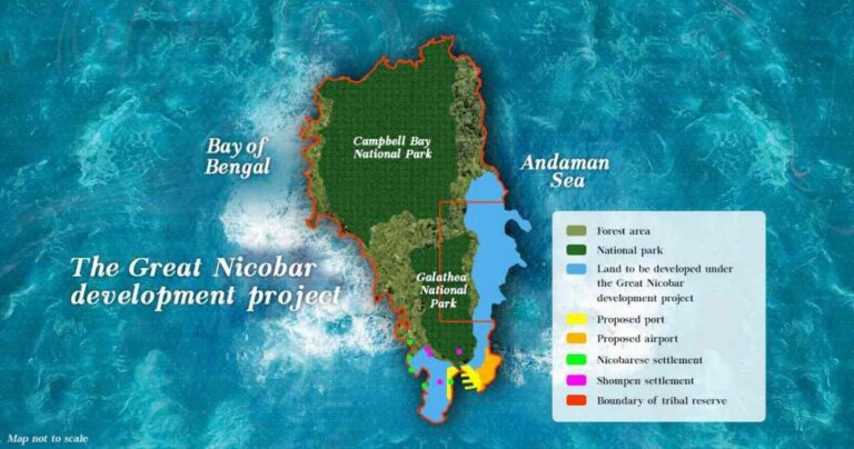
1. International Container Transshipment Terminal (ICTT)
o Location: Galathea Bay.
o Capacity: ~16 million TEUs.
o Purpose: Reduce dependence on foreign ports like Colombo and Singapore by positioning India as a global shipping hub.
2. Greenfield International Airport
o Civil–military dual-use design.
o Passenger capacity: ~4,000 per hour by 2050.
o Enhances logistical and defence readiness of the Andaman & Nicobar Command.
3. Township Development
o Planned population: 3–4 lakh.
o Includes residential, commercial, and institutional zones.
4. Power and Infrastructure
o 450 MVA gas and solar-based power plant.
o New road networks, water supply, and communication facilities.

Strategic Significance:
Location Advantage
- Six Degree Channel: A vital maritime passage close to Great Nicobar, adjacent to the Malacca Strait, through which 30–40% of global trade and much of China’s energy imports pass.
- Proximity: Just 150 km from Indonesia, giving India enhanced access to Southeast Asia.
National Security and Defence
- Expands India’s surveillance and operational capacity in the Bay of Bengal and Andaman Sea.
- Provides a counterbalance to external strategic influences such as China’s “String of Pearls.”
- Strengthens Maritime Domain Awareness (MDA) and aligns with Quad security objectives.
Regional Connectivity and HADR
- Advances India’s Act East Policy by enhancing ties with ASEAN nations.
- Increases preparedness for Humanitarian Assistance and Disaster Relief (HADR) in Southeast Asia, a region frequently impacted by natural disasters.
Ecological Concerns:
Deforestation
- Government Estimate: Around 8.5 lakh trees will be felled.
- Independent Estimates: Range between 32–58 lakh trees.
- Criticism: Old-growth tropical forests cannot be recreated through compensatory afforestation.
Biodiversity Risks
- Threats to endemic and endangered species such as the Nicobar megapode, leatherback turtle, Nicobar macaque, and coral reef ecosystems.
- Concerns that proposed infrastructure overlaps with turtle nesting grounds and fragile coastal ecosystems.
Seismic Vulnerability
- The island subsided ~15 feet during the 2004 Indian Ocean tsunami.
- Being a high-risk seismic and tsunami-prone zone, large-scale infrastructure faces questions of disaster resilience.
Tribal and Legal Concerns:
Indigenous Communities
- Home to the Nicobarese and Shompens, both classified as Particularly Vulnerable Tribal Groups (PVTGs).
- Some communities displaced by the 2004 tsunami were planning to return to ancestral lands, raising concerns about permanent loss of traditional spaces and livelihoods.
Forest Rights Act, 2006
- Mandates recognition of community and individual rights of Scheduled Tribes over forest land.
- Critics argue project clearances were granted without comprehensive consultations.
Government’s Position
- No tribal displacement is planned.
- Of the 166.10 sq. km project area, 73.07 sq. km of Tribal Reserve will be denotified, while 76.98 sq. km will be re-notified, leading to a net addition of 3.91 sq. km.
- Tribal councils and institutions such as the Anthropological Survey of India have been consulted.
- Dedicated committees have been set up for the welfare of Shompen and Nicobarese communities.
Environmental Safeguards and Government Response:
- Compensatory Afforestation: To be undertaken in Haryana due to lack of available land in the islands.
- Biodiversity Conservation: Over ₹81 crore allocated to scientific institutions such as ZSI, BSI, SACON, and WII.
- Infrastructure Design: Incorporates wildlife corridors, viaducts, and mitigation for arboreal and coastal species.
- Energy Mix: Reliance on solar and gas-based power to limit carbon footprint.
- Regulatory Oversight: Environmental Impact Assessment (EIA) and Environmental Management Plan (EMP) approved under EIA Notification, 2006.
Critics emphasise risks of deforestation, seismic vulnerability, and violation of tribal safeguards, calling for independent reviews. The government defends the project as a cornerstone of the Act East Policy, arguing that compensatory measures and phased planning balance economic, ecological, and social dimensions.
|
About Andaman & Nicobar Islands
Legal Safeguards · Article 338A: Provides for the National Commission for Scheduled Tribes, which must be consulted on policies affecting STs. · Coastal Regulation Zone (CRZ) Rules: Protect ecologically sensitive coastal stretches. · Forest (Conservation) Act, 1980: Restricts diversion of forest land for non-forest purposes. |
Conclusion:
The Great Nicobar Project encapsulates India’s development dilemma: advancing strategic and economic imperatives in ecologically fragile and socially sensitive zones. Its location near the Malacca Strait offers India unmatched maritime leverage, making it a potential hub for trade, security, and disaster response in the Indo-Pacific.
| UPSC/PSC Main question: “The Great Nicobar Project reflects the dilemma of pursuing strategic infrastructure in ecologically fragile zones.” Discuss. |


