Context:
In recent times, North India, including states like Bihar, Uttar Pradesh, Uttarakhand, Haryana, Delhi, and Punjab, has been grappling with heavy fog, affecting daily life and transportation. To keep the public informed, the India Meteorological Department (IMD) utilizes advanced satellite technology, particularly imagery from INSAT 3D and INSAT 3DR satellites. These satellites play a crucial role in monitoring and predicting weather conditions, providing valuable data for meteorological observations.
INSAT Satellites and Weather Tracking:
The primary satellites employed for weather monitoring in India are the INSAT 3D and INSAT 3DR. These geostationary satellites, orbiting at inclinations of 82 degrees and 74 degrees east longitudes, respectively, are equipped with advanced instruments to collect data on various atmospheric parameters. The satellites' capabilities have evolved over time, with each new iteration featuring improvements in spatial resolution, spectral channels, and functionality.
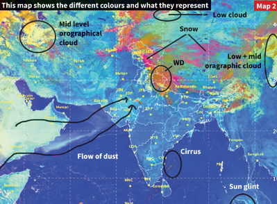
Color Representation in IMD Weather Maps:
The IMD utilizes maps generated from the INSAT 3D and INSAT 3DR satellites to convey weather information effectively. The color representation on these maps is crucial for understanding different meteorological phenomena. The color scheme is based on solar reflectance and brightness temperature, determined by specific wavelengths.
For example, the INSAT 3D's 'day microphysics' data component studies solar reflectance at three wavelengths: 0.5 micrometers (visible radiation), 1.6 micrometers (shortwave infrared radiation), and 10.8 micrometers (thermal infrared radiation). The strength of signals in these wavelengths determines the amount of green, red, and blue colors on the map. This color scheme aids in analyzing various cloud types, thunderstorm stages, snow areas, and fire detection.
Snow Tracking Using Shortwave Infrared Radiation:
Snow tracking is a notable application of the INSAT satellites' color scheme. While both snow and clouds exhibit similar solar reflectance in the visible spectrum, snow strongly absorbs radiation at a wavelength of 1.6 micrometers (shortwave infrared). As a result, when the satellite tracks snow, the red component of the color scheme becomes weak, distinguishing it from other cloud types.
Night Microphysics Component:
The 'night microphysics' component of the satellite imagery involves determining colors based on the strength of differences between two signals. For instance, the amount of red color is determined by the difference between two thermal infrared signals (12 micrometers and 10 micrometers). The amount of green color varies based on the difference between a thermal infrared signal and a middle infrared signal (10.8 micrometers and 3.9 micrometers). The amount of blue color, however, is determined solely by the strength of a thermal infrared signal at 10.8 micrometers.
Combining Day and Night Microphysics Data:
By combining day and night microphysics data, atmospheric scientists can gain insights into moisture droplets' presence, different cloud types, and temperature differences over time. This information is crucial for tracking the formation, evolution, and depletion of cyclones and other weather events. For instance, the INSAT 3D can produce images indicating the impending onset of a thunderstorm in one to three hours, leveraging signals from multiple wavelengths.
Role of Radiometers and Atmospheric Sounders:
To collect spectral measurements and understand various atmospheric characteristics, both INSAT 3D and INSAT 3DR are equipped with radiometers and atmospheric sounders. Radiometers measure properties of radiation, such as solar reflectance and brightness temperature, while atmospheric sounders focus on temperature, humidity, and water vapor as functions of height from the ground. Combining data from these instruments provides a comprehensive picture of the atmosphere, aiding in accurate weather predictions.
Evolution of INSAT Satellites in India:
India has a history of employing advanced satellite technology for weather monitoring. The INSAT 3D and INSAT 3DR satellites represent significant advancements over their predecessors. For example, the radiometer on INSAT 3DR is an upgraded version of the Very High-Resolution Radiometer (VHRR) used by earlier satellites like Kalpana 1 and INSAT 3A. These upgrades include improvements in spatial resolution, spectral channels, and overall functionality, enhancing the satellites' capabilities for meteorological observations.
Upcoming INSAT 3DS Satellite:
In February 2024, the Indian Space Research Organisation (ISRO) plans to launch the INSAT 3DS meteorological satellite aboard the GSLV Mk II launch vehicle. With a launch mass of two tonnes, INSAT 3DS aims to further enhance India's weather monitoring capabilities. The "3DS" designation signifies its status as the "3D second repeat," emphasizing the continued commitment to advancing and refining weather satellite technology.
Conclusion:
Satellite technology, exemplified by INSAT 3D and INSAT 3DR, has revolutionized the way we monitor and understand weather patterns. The intricate color schemes derived from solar reflectance and brightness temperature provide valuable insights into cloud types, snow areas, and impending weather events. Radiometers and atmospheric sounders contribute crucial data for a comprehensive understanding of atmospheric conditions. As India looks forward to the launch of INSAT 3DS, it underscores the nation's commitment to staying at the forefront of meteorological advancements, ensuring accurate and timely weather predictions for the well-being of its citizens.
|
Probable Questions for UPSC Mains Exam 1. Explain how INSAT 3D and INSAT 3DR satellites, through their color representation schemes, contribute to effective weather monitoring in North India. Discuss their role in analyzing meteorological phenomena and highlight the significance of the upcoming INSAT 3DS satellite. (10 marks, 150 words) 2. Trace the evolution of INSAT satellites in India, emphasizing technological improvements from earlier versions to INSAT 3D and INSAT 3DR. Briefly discuss enhancements in spatial resolution and spectral channels, and elucidate the importance of radiometers and atmospheric sounders in advancing accurate weather predictions.(15 marks, 250 words)
|
Source – The Hindu


