Context-
The Siachen Glacier, often referred to as the world’s highest and coldest battlefield, holds immense strategic significance as it sits at a crucial location between Pakistan and China. This frozen expanse, with Indian military presence for over four decades, remains a testament to enduring conflict and geopolitical complexities. On April 13, 1984, India preemptively occupied the glacier, executing Operation Meghdoot to thwart Pakistan’s mounting military actions and secure this critical terrain. This operation marked the beginning of a prolonged and challenging military endeavor, navigating extreme weather conditions and diplomatic intricacies.
|
40 years since 'Operation Meghdoot ● The Indian Army recently commemorated 40 years since 'Operation Meghdoot' began, securing the Siachen Glacier ● Siachen has been a bone of contention between India and Pakistan ever since the Karachi Agreement of 1949 when the area was left undivided due to the hostile terrain and extremely rough weather. ● Operation Meghdoot was India’s bold military response to what New Delhi calls Pakistan’s “cartographic aggression” in the uncharted territory of Ladakh, north of map reference NJ9842, where New Delhi and Islamabad had agreed the Line of Control (LoC) ran up to. ● It is distinguished by being one of the greatest examples of seamless coordination and synergy between the Indian Army and the Air Force. ● The military action resulted in Indian troops gaining control of the entire Siachen Glacier. Strategic Importance of the Siachen: ● Located at a height of around 20,000 feet in the Karakoram Mountain range, the Siachen Glacier is known as the highest militarised zone around the world. ● It is located so strategically that while it dominates Shaksgam Valley (ceded to China by Pakistan in 1963) in the north, controls the routes coming from Gilgit Baltistan to Leh from the west, and at the same time, it dominates the ancient Karakoram Pass in the eastern side too. ● Further, towards the west, it observes nearly the entire of the Gilgit Baltistan, which too is an Indian territory illegally occupied by Pakistan in 1948. |
Strategic Significance and Geopolitical Context
The Siachen Glacier, situated within the Karakoram ranges, serves as a pivotal geographic point with Pakistan on one side and China on the other. The region's terrain, characterized by high-altitude passes and barren landscapes, poses formidable challenges for military operations. Both India and Pakistan lay claim to this area, stemming from historical interpretations of partition agreements and strategic interests. Pakistan's ambitions extend towards establishing connectivity with China, heightening tensions and underscoring the glacier's strategic value.
In the 1970s and 1980s, Pakistan's engagement with foreign mountaineering expeditions aimed to bolster its territorial claims through cartographic maneuvers. India's preemptive response in 1984, driven by intelligence warnings, underscores the gravity of the strategic contestation over Siachen. Operation Meghdoot was a decisive move to secure the glacier, spearheaded by the Indian Army's calculated deployment and the Indian Air Force's critical aerial support.
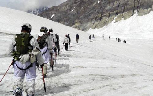
Operation Meghdoot: Implementation and Challenges
The genesis of Operation Meghdoot emerged from meticulous reconnaissance expeditions led by Colonel Narinder 'Bull' Kumar, providing vital intelligence for operational planning. On April 13, 1984, Indian forces executed a daring maneuver, planting the national flag at Bilafond La, thereby asserting control over this icy expanse. This marked the beginning of a prolonged engagement, characterized by extreme weather conditions and logistical hurdles.
In the subsequent years, Indian troops fortified positions across the glacier, engaging in sporadic confrontations with Pakistani counterparts. The harsh climate, with temperatures plummeting to -60 degrees Celsius, posed acute challenges to troop endurance and operational effectiveness. India's military operations expanded to include strategic airlifts, reconnaissance missions, and air support operations, leveraging a diverse fleet of helicopters and transport aircraft.
Operational Evolution and Technological Advancements
Over the decades, Operation Meghdoot has witnessed significant advancements in technology and logistical support. The Indian military's adaptation to high-altitude warfare has been marked by innovations in habitat construction, communication infrastructure, and mobility solutions. Notably, the introduction of VSAT technology revolutionized real-time situational awareness, enabling enhanced telemedicine capabilities and troop connectivity.
The logistical challenges posed by Siachen's remoteness and inhospitable conditions spurred the induction of specialized equipment like All-Terrain Vehicles (ATVs), Chinook heavy-lift helicopters, and logistic drones. These innovations bolstered supply chains, ensuring continuous provisions to isolated posts even during harsh winters. Moreover, advancements in medical facilities, including high-altitude pulmonary oedema (HAPO) chambers and telemedicine nodes, have significantly enhanced soldier welfare and survivability.
Diplomatic Implications and Geopolitical Stalemate
Despite diplomatic overtures and intermittent dialogues, the Siachen conflict remains emblematic of broader India-Pakistan disputes. Efforts towards demilitarization have faltered amid divergent interpretations of the Actual Ground Position Line (AGPL) and broader strategic considerations. India's steadfast stance on safeguarding Siachen underscores its centrality in countering collusive threats from Pakistan and China, reflecting evolving security dynamics in the region.
The broader geopolitical landscape, compounded by recent tensions along the Line of Actual Control (LAC) with China, has further entrenched Siachen's strategic significance. The glacier's proximity to the Shaksgam valley, ceded by Pakistan to China in 1963, accentuates its broader implications within the context of regional power dynamics. As such, Siachen remains a focal point in India's strategic calculus, reflecting enduring security imperatives amid evolving geopolitical challenges.
Conclusion:
In conclusion, the Siachen Glacier epitomizes the enduring contestations and strategic imperatives shaping South Asia's security landscape. Operation Meghdoot, spanning over four decades, underscores India's unwavering commitment to safeguarding this critical terrain amid complex geopolitical dynamics. Despite technological advancements and diplomatic engagements, Siachen remains emblematic of unresolved conflicts and broader regional rivalries. Moving forward, addressing Siachen's strategic challenges necessitates comprehensive dialogue and concerted efforts toward enduring peace and stability in the region.
|
Probable Questions for UPSC Mains Exam- 1. How has the strategic importance of the Siachen Glacier evolved over the decades, particularly in the context of regional geopolitical dynamics involving Pakistan and China? ( 10 Marks, 150 Words) 2. What were the key operational challenges faced during Operation Meghdoot, and how did the Indian military adapt technologically and logistically to sustain operations in the extreme high-altitude conditions of the Siachen Glacier? ( 15 Marks, 250 Words) |
Source - The Hindu


