Relevance: GS-2:India and its neighbours
Key phrases: Mansarowar Yatra , Indo-Nepal Friendship Treaty 1950, Treaty of Saugauli 1816, river boundary with Nepal , Lipulekh Pass
Context
- Recently an announcement was made by PM that India is further widening the road built in Lipulekh in Uttarakhand.
- In response Nepal minister asserted that territories, including Limpiadhura, Lipulekh and Kalapani East of Kali River, are an integral part of Nepal and any construction or expansion of roads thereby India must be stopped.
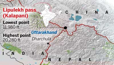
Where is Lipulekh pass and why is it important?
- Lipulekh sits atop the Kalapani Valley and forms a tri-junction between India, Nepal and China and has been used for centuries by Hindu and Buddhist pilgrims and tourists on their way to Kailash Mansarovar since its opening in 1982
- The Pass was never used by Nepal. The route as a trade and transit passage was legitimated by India and China through an agreement on Trade and Intercourse with Tibet signed in 1954, which stated that the traders and pilgrims from both the countries could travel by Lipulekh.
- Lipulekh is strategically located as it is nearest to the National Capital Region and can be of particular concern in case of an armed conflict with China.
- When pilgrimage to Kailash Mansarovar paused with the takeover of Tibet by Chinese forces in the mid-1950s, India deployed troops at the Lipulekh pass in 1959.
Do you know?
- In 1954, India and China signed a trade treaty, agreeing Lipulekh pass as the Indian gateway.
- In 1962, India shut the Lipulekh pass fearing more Chinese incursions. Nepal is not known to have objected to its closure.
The Darchula-Lipulekh road
- The Darchula-Lipulekh road is an extension of Pithoragarh-Tawaghat-Ghatiabagarh road.
- It originates from Ghatiabagarh and terminates at Lipulekh Pass, the gateway to Kailash Mansarovar.
- On this 80 Km road, the altitude rises from 6000 feet to 17,060 feet.
- Nepal asserted that the road passed through its territory.
Importance of the wide motorable road to Lipulekh
- The road is important for “strategic, religious and trade” reasons.
- Significant for the annual Kailash Masarovar Yatra. With the completion of this project, the arduous trek through treacherous high-altitude terrain can now be avoided by the pilgrims of Kailash Mansarovar Yatra and the period of journey will be reduced by at least 6 days.
- The government has underlined that through this improved route, yatris do not need the alternative routes now available for the pilgrimage, one through the Nathu La border in Sikkim and the other via Nepal, which entailed “20 per cent land journeys on Indian roads and 80 per cent land journeys in China … the ratio has been reversed. Now pilgrims to Mansarovar will traverse 84 per cent land journeys on Indian roads and only 16 per cent in China.”
- It would now be possible to complete the entire distance from Delhi to Lipulekh in 2 days
- The new road is also expected to provide better connectivity to Indian traders for the India-China border trade at the Lipu Lekh pass between June and September every summer.

Location of Kalapani region
- It is situated on the Kailash Mansarovar route. It shares a border on the north with the Tibet Autonomous Region of China and Nepal in the east and south.
- The region resembles a slice of cake wedged in between Limpiyadhura, Lipulekh and Kalapani.
- The area is in India’s control but Nepal claims the region because of historical and cartographic reasons.
- The area is the largest territorial dispute between Nepal and India consisting of at least 37,000 hectares of land in the High Himalayas.
The Sugauli Treaty (1816) and thereafter
- Treaty of Sugauli was signed between the Gurkha rulers of Kathmandu and the East India Company after the Gurkha War/Anglo-Nepal War (1814-16).
- The Sugauli Treaty locates the river Kali as Nepal’s western boundary with India.
- The British in 1860's shifted their military base to Kalapani, closer to the source of the River Kali. This arrangement continued till 1947. In fact the terms were reiterated by a second treaty between Nepal and British India in 1923.
- India and Nepal signed a friendship treaty in 1950 to formalise ancient ties in post-colonial era. Nepal was more aligned towards India for decades. And, the Chinese occupation of Tibet in 1950-51 left it to India to secure the combined India-Nepal border in the region.
Causes of the dispute related to Kalapani region
- The rival territorial claims over Kalapani region by India and Nepal is due to divergent views related to the source of river Kali.
- Both sides have their own British-era maps as proof of their positions.
- Maps drawn by British surveyors show the source of the boundary river at different places. This discrepancy in locating the source of the river led to boundary disputes between India and Nepal, with each country producing maps supporting their own claims.
- Nepal’s case is that the river originates from a stream at Limpiyadhura, north-west of Lipulekh. Thus Kalapani, and Limpiyadhura, and Lipulekh, fall to the east of the river and are part of Nepal’s Far West province in the district of Dharchula.
- India’s position is that the border begins at Kalapani which India says is where the river begins. India contends that the river actually takes the name Kali near Kalapani.
- Further India holds that Kali originates in springs well below the pass, and that though the Treaty does not demarcate the area north of these springs but administrative and revenue records going back to the 19th century shows that Kalapani was on the Indian side, and counted as part of Pithoragarh district, now in Uttarakhand.
Who is in possession of the region?
- Kalapani is under the territorial jurisdiction of India and after the British left India, it maintained a police post in Kalapani since mid-1950's.
- From 1979-80, the Indo-Tibetan Border Police (ITBP) has been manning the boundaries.
- India maintains a strict border regime to keep out criminals and control illegal cross-border activities from Nepal.
Revival of dispute over Kalapani between India and Nepal- Recent Events
- In November 2019 when India published a revised political map showing the newly created Union Territories of Jammu and Kashmir and Ladakh, the dispute over Kalapani, which lies on the easternmost corner of Uttarakhand’s Pithoragarh district, between Nepal and India was revived.
- In the new political map of India all other boundaries except that of Jammu and Kashmir and Ladakh remained as has always been shown since 1947.
- Nepal raised an objection to the map while asserting claim over Lipulekh pass, Limpiyadhura pass and Kalapani along with Gunji, Nabi and Kuti villages.
- Both India and Nepal claim Kalapani as an integral part of their territory - India as part of Uttarakhand’s Pithoragarh district and Nepal as part of Dharchula district.
- Meanwhile India inaugurated the Darchula-Lipulekh pass link road, cutting across the disputed Kalapani area which is used by Indian pilgrims to Kailash Mansarovar.
- In 2020 Nepal released a new political map that claims Kalapani, Limpiyadhura and Lipulekh of Uttarakhand as part of Nepal’s territory. The new map with the aforementioned territory was unanimously passed by Nepal’s Parliament. The area of Susta (West Champaran district, Bihar) can also be noted in the new map.
Do you know?
- Currently, India and Nepal have border disputes over
- Kalapani - Limpiyadhura - Lipulekh trijunction between India-Nepal and China and
- Susta area (West Champaran district, Bihar).
- Lipulekh pass was opened for trade in 1992.
Lipulekh agreement between India and China
- In 2015 Lipulekh agreement between India and China renewed India’s Mansarovar pilgrimage connection.
- Neither side consulted Nepal or sought its opinion before that agreement that boosted pilgrimage and trade to Tibet.
- This means that till very recently China has recognised Lipulekh as part of India.
Conclusion
- Although the Government of India’s position on the India-Nepal boundary is well known, consistent and unambiguous, yet given the fact that as close neighbours, India and Nepal share a unique relationship of friendship and cooperation characterized by open borders and deep-rooted people–to–people contacts of kinship and culture, they should try to resolve the boundary dispute through diplomacy and dialogue.
Mains Question:
Q. The Kalapani region issue raised by Nepal recently shall not stand the scrutiny of history. Substantiate (150 words/10 marks )


