Date : 27/09/2023
Relevance – GS Paper 3 – Science and Technology
Keywords – Geospatial Intelligence, National Geospatial Policy 2022, GIS, GPS
Context –
Geospatial intelligence plays a pivotal role in assisting governments and organizations worldwide in safeguarding communities from a variety of threats. It provides essential insights and data, transcending geographical boundaries, to address the impacts of extreme weather events and natural disasters.
What is Geospatial intelligence?
Geospatial intelligence involves gathering and harmonizing information from diverse sources such as satellites, sensors, and aerial imagery to generate live maps and simulations. It serves in recognizing and handling risks, bolstering emergency responses, overseeing environmental conditions, streamlining logistics, and other applications.
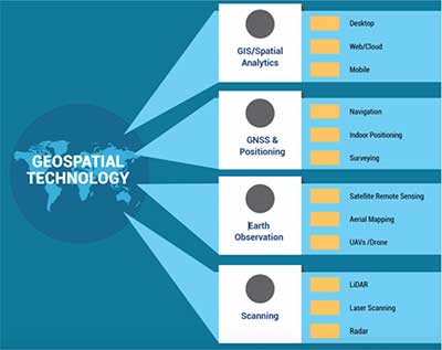
Geospatial technology employs instruments like GIS (Geographic Information System), GPS (Global Positioning System), and Remote Sensing for geographic mapping and the comprehensive analysis of geospatial data.
National Geospatial Policy 2022 Overview:
The National Geospatial Policy 2022 is centered around citizen-centric principles and harnesses Geo-Spatial technology to fortify the Geospatial sector, bolster national development, foster economic growth, and cultivate a robust information economy. Key facets of this policy include:
Vision and Goals:
- The policy aspires to position India as a global leader in the Geospatial domain, fostering an innovation-friendly ecosystem.
- It seeks to establish a cohesive national framework to propel the nation towards a digital economy and enhance citizen services.
- Goals encompass the development of Geospatial infrastructure, expertise, standards, and businesses while promoting innovation and reinforcing national and sub-national capacities for Geospatial information management.
Institutional Framework:
- At the national level, a Geospatial Data Promotion and Development Committee (GDPDC) is envisioned as the apex body responsible for devising and executing Geospatial sector promotion strategies.
- GDPDC will replace and absorb the functions and authority of the National Spatial Data Committee (NSDC) established in 2006 and the GDPDC of 2021.
- The Department of Science & Technology will continue as the nodal department, with GDPDC making recommendations in line with the Geospatial regime.
Milestones:
- By 2025, the policy aims to create an accommodating policy and legal structure that facilitates Geospatial sector liberalization, democratizes data for commercialization, and enhances value-added services.
- By 2030, the goal is to achieve high-resolution topographical survey and mapping, including a Digital Elevation Model (DEM).
- By 2035, the policy targets high-resolution/accuracy Bathymetric Geospatial Data for inland waters and sea surface topography, supporting the Blue Economy.
- It also envisions the establishment of a National Digital Twin for major cities and towns, fostering an ecosystem of interconnected Digital Twins.
Significance:
- Geospatial technology and data are instrumental in advancing Sustainable Development Goals (SDGs).
- The policy promotes startups and reduces dependency on foreign resources.
- Geospatial data is pivotal in critical applications such as military operations, disaster management, environmental monitoring, and urban planning.
The Geospatial Landscape in India:
India boasts a robust geospatial ecosystem, with key players including the Survey of India (SoI), the Indian Space Research Organisation (ISRO), Remote Sensing Application Centres (RSACs), and the National Informatics Centre (NIC). These entities, along with various ministries and departments, extensively utilize geospatial technology.
As of 2021, the geospatial market in India demonstrated prominence in sectors such as defence and intelligence (14%), urban development (13%), and utilities (11%). These segments collectively constituted 38% of the overall geospatial market, reflecting their significance and influence.
Key Applications of Geospatial Intelligence:
1. Emergency Preparedness:
- Monitoring natural disasters like cyclones and hurricanes to allocate resources efficiently, issue timely storm warnings, and order evacuations as needed.
2. Disaster Response:
- Assisting in post-disaster efforts by identifying damaged areas, assessing the extent of impact, locating access points for first responders, and facilitating efficient search-and-rescue operations and aid distribution.
3. Environmental Monitoring:
- Tracking climate-related variables such as temperature, precipitation, and ice to anticipate and prepare for environmental disturbances, including heatwaves, floods, and polar ice melt.
4. Military and Civilian Applications:
- Reporting on military movements, troop deployments, and providing valuable spatial data for civilian applications like global supply chain optimization and logistics management.
5. Transportation and Logistics:
- Utilizing GPS-generated spatial data to enhance transportation and logistics operations.
6. Autonomous Vehicles:
- Supporting the development of autonomous vehicles by providing high-resolution imagery for road analysis and traffic management.
7. Digital Twins:
- Creating virtual replicas of real-world systems like cities and buildings, which can be updated in real-time to simulate changes in various conditions, aiding decision-making across sectors including military and urban planning.
Measures for Advancing Geospatial Data and Technology:
1. Guidelines for Geospatial Data, 2021:
- Released in 2021 by the Ministry of Science and Technology.
- Deregulated and liberalized the Geospatial Sector in India, enhancing competitiveness.
- Removed the need for permissions and scrutiny, including security concerns, for Indian companies.
- Companies can now self-attest, complying with government guidelines without continuous monitoring by a government agency.
2. Geospatial Energy Map of India:
- Developed in collaboration with NITI Aayog and ISRO.
- Offers a comprehensive view of energy production and distribution in the country.
- Supports planning, investment decisions, and disaster management using available energy assets.
3. Union Budget 2022-23:
- Government support for using Kisan drones for land assessment, digitizing land records, and applying insecticides and nutrients.
4. National Geospatial Policy, 2022:
- A 13-year guideline aimed at promoting India's geospatial data industry and establishing a national framework for enhancing citizen services and more.
5. Yuktahara Portal:
- Functions as a repository of geotagged assets created under various National Rural Development Programs, including MGNREGA, Per Drop More Crop Programs, Integrated Watershed Management Programme, and Rashtriya Krishi Vikas Yojana.
Challenges Associated with Geospatial Technology:
1. Security Concerns:
- Reluctance to share data arises from fears that malicious entities like terrorists or criminals could exploit the information for illicit purposes.
2. Privacy Concerns:
- India lacks a dedicated data protection policy, leading to potential privacy issues when using Geospatial data.
3. Data Availability and Sharing Constraints:
- Limited access to foundational data, particularly at high resolutions, poses a challenge.
- Ambiguity surrounding data sharing and collaboration hinders co-creation and optimal asset utilization.
Actions for Improvement:
1. Establish a Competent and Specialized Team:
- Develop a trained and dedicated team proficient in utilizing geospatial data effectively.
2. Allocate Adequate Funding:
- Provide funding to expand and enhance the application of geospatial technology across various sectors and initiatives.
3. Prioritize Privacy:
- Ensure that privacy considerations are integrated into the use of geospatial data, aligning with data protection and privacy regulations.
Conclusion
Presently, the accessibility of high-resolution satellite imagery fosters a favorable atmosphere highlighting the importance of this technology in monitoring integrated systems for various aspects of national security. Consequently, geospatial technology reduces the time required for analysis and enhances the capacity and effectiveness of decision-making in matters related to national security.
Probable Questions for UPSC Mains Exam
- Explain the applications of geospatial intelligence in disaster response and emergency preparedness for national security. Provide real-world examples. (10 marks, 150 words)
- Describe India's initiatives to promote geospatial data and technology development. What are the challenges and privacy issues associated with its use in national security, and how can they be managed effectively? (15 marks, 250 words)
Source – The Hindu


